

On Sunday, a tropical storm formed in the northern Caribbean Sea. Although few forecast models were predicting it would reach major hurricane status at the time, it seemed possible given that the storm was now moving away from the Yucatan Peninsula landmass and toward warmer waters in the southern Gulf of Mexico, where it will encounter lower overall wind shear.
By late Monday morning, Michael had become a hurricane, and forecasters at the National Hurricane Center now officially expect it to be a major Category 3 by Wednesday. That's when Michael will make landfall along the northern Gulf coast, likely over the Florida Panhandle. The biggest concerns for the Florida coastline, particularly an area between Destin and Apalachicola, are strong winds and a damaging storm surge. Inland areas such as Tallahassee will also see significant effects. Rainfall is a lesser threat due to the storm's progressive movement to the north.
It is rare but certainly not unheard of for major hurricanes to strike the United States in October—after all, the season does not end until November 30. However, by the middle of October, we are nearing the end of the season in terms of the greatest threat of hurricanes to land.
Since 1851, when semi-accurate record keeping began, especially for landfalling storms, a total of 15 major hurricanes have hit the United States. A major hurricane is defined as Category 3 or greater on the Saffir-Simpson scale, with sustained winds of 111mph or greater. (The 11am ET forecast on Monday from the National Hurricane Center calls for 120mph winds for Michael at landfall).
Another Wilma for Florida?
That Michael will move toward Florida should not come as a great surprise. In October, the climatology of storms favors a northward turn—i.e., instead of moving due westward into Texas, storms in the Gulf of Mexico often curve north into Florida. That's a result of upper-level patterns that are starting to bring cold fronts down across the Central Plains states and into Texas.
According to Colorado State University hurricane scientist Phil Klotzbach, of the 15 major hurricanes that have struck the United States in October since 1851, 10 of them have hit Florida. The most recent was Hurricane Wilma during the incredibly active season of 2005.
Forecasters also measure hurricane intensity by central pressure, with lower pressures denoting a tighter circulation, better organization, and more powerful storm. Wilma was a super-intense hurricane in the northwestern Caribbean Sea in October 2005. Its central pressure of just 882 millibars set the record for lowest central pressure of any Atlantic hurricane on record. Fortunately, Wilma weakened before making landfall on October 24 in Cape Romano, Florida, which is about 175 miles south of Tampa. Wilma had sustained winds of 120mph, with a central pressure of 950mb.
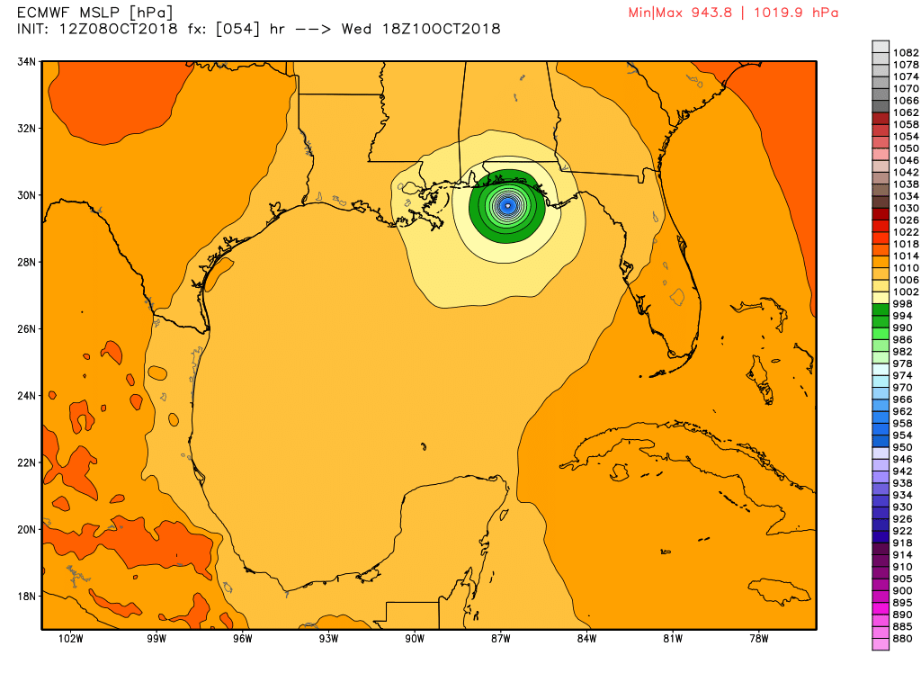
That is close to what we can probably expect from Michael at landfall. The latest, 12z operational run of the European model shows Michael reaching a central pressure of 943.8mb shortly after noon on Wednesday, before making landfall along the Florida coast. Wilma remains the eighth-costliest hurricane to strike the United States, with an estimated $27.4 billion in damages. Needless to say, Michael should be taken seriously.
[contf] [contfnew] 
Ars Technica
[contfnewc] [contfnewc]


