

HOUSTON—Jeffry Evans mobile phone rang shortly before 3am, local time, instantly waking him from a deep slumber.
Not good, he instinctively knew.
The Houston meteorologist had crashed late on Monday, August 24. Before hitting the mattress around midnight, he left instructions to be awakened if the forecast for Hurricane Laura took a turn for the worse. And now it had. By early Tuesday, the overnight model guidance indicated a high probability the storm may take a more westerly track across the Gulf of Mexico and strike the fourth largest US city.
Evans serves as “meteorologist in charge” of the National Weather Service office that covers the Houston-Galveston region, which has a population well north of 7 million. One of the forecasters at his office had just been briefed by the National Hurricane Center. Concerns were rising about a strike near Houston.
So Evans rubbed his eyes as he checked the forecast models for himself, at home, in the middle of the night. As he reviewed the latest data, the outlook appeared pretty grim. The worlds best forecast model, run by a Europe-based organization, projected a landfall near Houston. Moreover, its ensemble suite, which provides broader perspective, showed a landfall further south. This represented pretty much the worst-case scenario for the largest city on the Gulf of Mexico.
Houston would lay to the right of such a landfalling hurricane, taking the full force of its screaming winds and watching neighborhoods flatten. Massive waves would roll into Galveston Bay and, from there, funnel into the Houston Ship Channel. There, barely a dozen feet above sea level, large refineries process about 15 percent of the nations petroleum. Countless other chemical companies also have facilities along the waterway. The economic and environmental catastrophe would be almost beyond calculation.
Evans also thought about his own situation. He lived near the National Weather Service office, which is located a few miles from Galveston Bay. Evans spared a few minutes to consider how best to prepare his home for the worst, and whether his wife and their 40- and 80-pound dogs should evacuate.
After quickly assessing the forecast, Evans picked up his cell phone and texted Jeff Lindner, the lead forecaster at Harris County Flood Control District. Evans wanted to make sure officials at Harris County knew what was happening and understood the heightened threat faced by the community.
Houston is located in Harris County, and its chief executive, the “County Judge,” has the final say on local evacuations. A 29-year-old politician named Lina Hidalgo had surprisingly been elected to the position in 2018 after the formerly Republican county turned Democratic. This was her first hurricane. Now, the untested leader would be called upon to make the final evacuation decision.
Until Tuesday morning, it seemed that Houston probably would be spared the worst from Laura, but now Evans was not so sure. The hurricane would make landfall in less than 48 hours, cutting it close for the time needed to get hundreds of thousands of people away from the coast. Worse, Houston has a bad history with evacuations. Were an evacuation called, inland residents who did not need to flee might do so anyway, clogging roads for those who really needed to go. That had happened before. And if the National Hurricane Center was going to predict a landfall near Houston, that very well might precipitate an exodus.
Hidalgo had important decisions to make, and so Evans sent his text to Lindner. It was short and sweet: “You up?”
The Rita nightmare
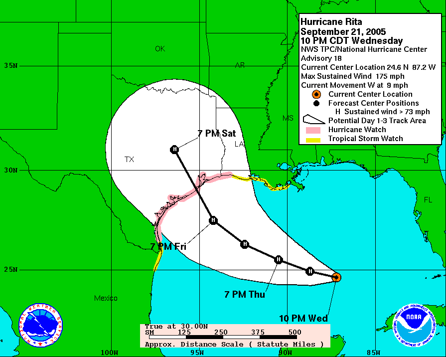
Houston experienced the nation's worst hurricane evacuation 15 years ago, when a storm named Rita menaced the state in late September. In some ways, this was the perfect storm to terrify a city built dozens of miles inland and dozens of feet above sea level.
Thats because Rita was an alarming storm. Late on the evening of September 21, 2005, Rita intensified to 175mph over the central Gulf of Mexico, and it was forecast to make landfall a little more than two days later just below Houston on the Texas coast.
“This was the worst-case scenario for Houston," said Bill Read, then the meteorologist-in-charge of the Houston/Galveston Office. He would go on to lead the National Hurricane Center for several years before retiring.
Another factor that contributed to the mass evacuation was Hurricane Katrina, which had made landfall three weeks earlier near New Orleans. The storm killed more than 1,000 people and produced dramatic images of flood-stricken residents pleading for rescue from their homes. A quarter of a million people had evacuated from the region to Houston, and nearly all were still here.
Finally, local officials did a poor job of messaging the need to “run from the water, and hide from the wind.” This basically means that residents of coastal areas need priority to evacuate first, due to their vulnerability to life-threatening storm surge. But this was not what then-Houston Mayor Bill White said a little less than three days before Rita made landfall. Instead, White urged his city to run for the hills, saying, “Don't wait. The time for waiting is over.”
Houston didnt wait. More than 3 million people got into their cars or onto hastily arranged school buses. These vehicles took to the roads. And then the regions freeways and highways, for more than 100 miles on the routes to Dallas, Austin, San Antonio, and elsewhere, came to a standstill. As they baked in their cars, beneath 100-degree heat, desperate drivers eventually turned off their AC to conserve fuel. Many ran out of gas anyway and roadside stations were quickly depleted.
The roads turned deadly. Normal three- or four-hour drives from Houston to other major Texas cities took 20 hours or more. A total of 67 people died due to heat stress, and 23 nursing home evacuees were killed in a bus fire. All told, an estimated 107 people died during this nightmare evacuation.
In the early morning hours of Thursday, Sept. 22, 2005, traffic is backed up as people leave the Houston area in of Hurricane Rita. Ken Cedeno/Corbis via Getty Images Vehicles jam the northbound lanes (R) of I-45 as the southbound lanes (L) are empty on September 22, 2005. The region had no plans to open contraflow lanes at the time. STAN HONDA/AFP via Getty Images Evacuees line up to board a bus at the Island Community Center September 21, 2005 in Galveston, Texas. But it wasn't just coastal residents who fled during Rita. Everyone did. Dave Einsel/Getty Images Airports were flooded with people. Lines of passengers wait at a security checkpoint on September 22, 2005, before flying out of George Bush Intercontinental Airport in Houston, Texas. STAN HONDA/AFP via Getty Images In parts of the city, traffic moved during the Rita evacuation. F. Carter Smith/Bloomberg via Getty Images But most of the time it was gridlock. Dave Einsel/Getty Images During a mandatory evacuation, nursing homes, hospitals, and prisons must also be evacuated. It is a logistical nightmare. Dave Einsel/Getty Images School buses: They're not just for school any more. JAMES NIELSEN/AFP via Getty Images
Rita ended up weakening more than forecasters intended after its inner core disintegrated. And much like Hurricane Laura, it approached the Texas coast and then turned north, making landfall near the states border with Louisiana. Houston ended up with a glancing blow and memories of the worst hurricane evacuation of all time
Since then, the region has learned some lessons. Its leaders understand the difference between evacuating coastal areas and regions well inland. However, local residents also remember Hurricane Ike, which came ashore in 2008 just east of Houston. It knocked out power for weeks. The threat of lost power, alone, would impel many inland residents to evacuate again, said Bob Stein, a political scientist at Rice University.
Finally, Houston has grown substantially since Rita. The Houston metro area population at the time was about 5 million, with the vast majority living in Harris County. By the time Hurricane Laura threatened the city, the metro population had grown by 40 percent. Houstons freeway lanes have not grown nearly as fast. Trying to get as many people out of the area, in less time, would be an unmitigated disaster.
Late night in Miami
As Evans and Lindner were winding down for the night on Monday, August 24, Eric Blake came on shift at the National Hurricane Center in Miami. As the forecaster on duty for the “midnight” shift, he was responsible for producing the official track forecast that would come out at 4am Houston time Tuesday morning. Normally there would be several other forecasters at the office to bounce ideas off, but during the COVID-19 pandemic there are only two forecasters in the office at the same time.
So this night, Blake was mostly on his own as he began studying aircraft reconnaissance data and satellite images to ascertain precisely where Lauras center was, how strong it was, and in what direction the storm was moving.
Like everyone else interested in hurricanes, Blake looked at track forecasts from models in what are called “spaghetti plots.” But he looked deeper into the actual model fields to see how each output was handling steering flow and other factors. “Hes not just blindly interpreting lines on a map,” said Michael Brennan, branch chief of the National Hurricane Centers hurricane forecaster unit.
Blake did note the overall westward shift in the guidance that night in pretty much all of the major global models. In particular, the “ensemble” forecasts had moved. In an ensemble model, dozens of lower-resolution versions of the primary model are run with slight variations on initial conditions. This provides a realistic range of possible outcomes. For Laura that night, the influential European model ensemble “mean” produced a Laura track south of Houston, in just about the worst possible location.
This is the official forecast at 10pm CT Monday, August 24. The Houston metro area is outlined. National Hurricane Center Here is the overnight ensemble forecast from the European model showing a spread over Texas. Weathermodels.com And here is the "mean" of the European model showing a landfall just south of Houston. Pivotal Weather And here is the forecast for 4am CT Tuesday by Eric Blake. Note only a slight westward shift. National Hurricane Center
But Blake chose not to react too strongly to this shift in guidance. Instead of moving the track 50 or even 100 miles to the west to mimic the models, he played it conservatively, only shifting the forecast about 20 miles west.
For anyone in Houston paying close attention early that morning, however, his forecast discussion was ominous: “The new NHC prediction is at the eastern edge of the new guidance envelope since I don't want to bite off on such a large change on just one set of model runs. But since the storm has been tracking west of forecast expectations for quite some time, future westward track adjustments could be required later today.”
Brennan said hurricane center forecasters are generally conservative, because they dont want forecasts to flip back and forth like windshield wipers. And in this case, they had solid reasons to believe the track east of Houston still might verify. The European ensemble seemed to be biased to the south, and so while it was concerning, the center was not ready to buy into this idea yet.
Crucially, most regular people do not read the forecast discussion—they mostly look at the “skinny black line” at the center of the National Hurricane Centers cone. For Laura, this still showed a landfall well up the coast from Houston, near the Texas-Louisiana border. And so as Eric Blake returned home on Tuesday morning, millions of people along the upper Texas coast looked at his forecast and assumed Houston probably would be spared the worst.
They did not panic.
Difficult decisions
Jeff Lindner rarely goes home from the office when severe weather threatens. During the Hurricane Harvey flood storm in 2017, Lindner had gained a measure of fame for his indefatigable updates on the regions swollen bayous, rivers, and streets. So he was napping early Tuesday at work when Evans text message awoke him.
He, too, took time to review all of the data. Then, in his early-morning update to local officials including Hidalgo, Lindner wrote about the overnight forecast model guidance now delaying Lauras northward turn “a little longer,” which would bring the storm closer to Houston. The National Hurricane Center, he said, “may have to shift their forecast track a bit more westward later this morning. Preparations for the landfall of a major hurricane along the upper Texas coast should be well underway.”
The regions governments coordinate their response to regional issues, including natural disasters, at the “Transtar” facility just northwest of downtown Houston. Lindner had been bunking down there. Hidalgo arrived at 8am, local time, on Tuesday morning.
“I went to bed on Monday night knowing that I would have to decide on Tuesday whether to call for an evacuation,” Hidalgo told Ars in an interview. “Im always expecting the worst, because I want to be positively surprised.”
Hidalgo would not be positively surprised. She had hoped for a clear signal in the models that moved Houston out of the National Hurricane Centers “cone.” Instead, when the models shifted westward, it put her in an extremely difficult position. Although a majority of scenarios still spared Houston from the worst, there was perhaps a one-in-four chance the region would take a direct hit from an intensifying hurricane.

She could not afford to wait much longer. Given the sprawling nature of Houston, transportation experts say it takes about 72 hours to conduct a full-scale evacuation of the region in advance of a hurricane. By Tuesday morning, she had fewer than 36 hours before tropical storm-force winds would potentially begin blowing across Houstons freeways.
Hidalgo hedged her bets by calling for a “voluntary” evacuation for some parts of the metro region closer to the coast. About 200,000 people lived in these areas that could potentially be impacted by storm surge. She hoped this would send a signal to coastal residents that they really needed to prepare for Laura, without setting off a panic like that which ensued during Hurricane Rita. If the forecast worsened later in the day, those evacuations would become mandatory.
It was not easy holding the line that morning on a full-fledged evacuation. The models were trending west, as they had been for days. Psychologically, it felt like they would continue to do so, and any further westward movement would place Houston in serious jeopardy. And the longer she waited, Hidalgo faced the risk of a last-minute evacuation—with stopped freeways battered by a hurricanes winds.
“Its never cut-and-dried with this kind of thing,” she said. “Thats why its important to have people who are intellectually honest to advise you.”
And so Lina Hidalgo listened to the experts, like Lindner and the National Hurricane Center. They were telling her the storm would probably remain east. However if it did not, the fault for what happened next would not be theirs—she knew she would own it.
A storm turns
By early Tuesday afternoon, the models had shifted again. In this case, however, they began to move back east. Slowly, confidence increased that Lauras worst would indeed miss Houston. Hidalgo never had to call for mandatory evacuations. The new data signaled relief for Houston but devastation in Southwestern Louisiana.
Bob Stein, the Rice researcher who studies the mindset behind evacuations, said there are many indicators that Houston residents were taking Laura seriously. Sales of plywood and bottled water had spiked in the region, and some people had already evacuated by Monday night. It would not have taken much of a spark to ignite a much more widespread evacuation. As neighbors see neighbors evacuating, he said, that increases the likelihood they will leave, too.
The conservative forecast from the hurricane center, and calm comments from local leaders like Read More – Source
[contf] [contfnew] 
arstechnica
[contfnewc] [contfnewc]


