

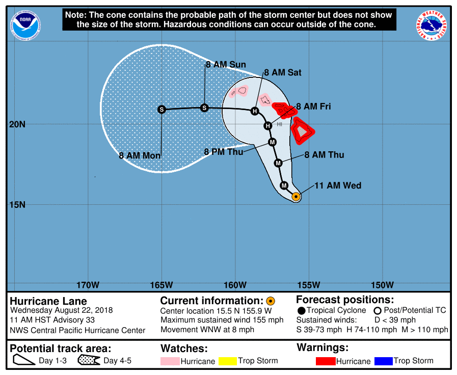
Wednesday 5:35pm ET Update: As of Wednesday afternoon, (late morning, Hawaii time), Hurricane Lane remains an extremely powerful Category-4 hurricane, with maximum sustained winds of 155mph. Fortunately, wind shear is now increasing over Lane, and these unfavorable winds should weaken Lane considerably over the next two to three days.
In terms of track, Lane now appears likely to make a northward turn later in the forecast, which probably—but not yet certainly—will keep its center away from the Hawaiian islands. The latest track update from the Central Pacific Hurricane Center in Honolulu is shown below.
Because of the revised track, winds are slightly less of a concern for Hawaii now. The probability of all major towns and cities in the islands receiving hurricane-force winds is now below 20 percent. Prolonged rainfall and life-threatening flash flooding remain the primary concern for Lane over the next several days.
Original post: For Hawaii, the "big one" came in 1992 when Hurricane Iniki struck the island of Kauai as a Category-4 storm, causing $3.2 billion in damage and killing six people. This remains the costliest and deadliest storm to hit the islands in recorded history, and only two other hurricanes—an unnamed storm in 1871 and Dot in 1959—have hit a Hawaiian island in that time frame. (Several readers have mentioned Hurricane Iwa, but this storm's center passed just north of the islands).
At only about 20 degrees north of the equator, Hawaii is well within the tropics, and therefore we might expect hurricanes to strike there more often. However, deep trenches in the Pacific Ocean near the islands facilitate the upwelling of significantly cooler water. Typically, sea surface temperatures near Hawaii are just below the 26.5° Celsius threshold that is favorable for hurricane formation and intensification. However, this year, sea surface temperatures are about 0.5 to 1.0 degrees above normal near the islands.
Unfortunately, this has increased the vulnerability of the Hawaiian Islands to hurricanes this year. Earlier this month, the Category-4 Hurricane Hector appeared to threaten the islands for a few days, but ultimately its track remained a few hundred kilometers to the south. Now, another major hurricane, Lane, seems considerably more likely to bring significant effects to the islands.
12z modeling
During the last day or so, forecast models have trended toward a more northward track that would bring Lane westward, then northwestward, before turning due north toward the Hawaiian Islands by Thursday or Friday. So far, the US-based Global Forecasting System model (GFS) has been the most consistent in terms of sticking to this path, which looks increasingly likely.
These plots show the trend in track for Hurricane Lane. The GFS model has been the most consistent. Brian Tang The European model has trended toward the GFS track in recent runs. Brian Tang So has the UK Met Office's model. Brian Tang
The latest global model forecasts, which include tracks for Lane, have come out between noon ET (1600 UTC) and 2pm (1800 UTC) on Tuesday. Pretty much all of the various global models (which forecast conditions around the world) and hurricane-specific models (which forecast individual cyclones) now show the storm making a turn toward Hawaii later this week.
As of Tuesday afternoon, the islands of Molokai, Lanai, Maui, and the Big Island are all under a hurricane watch.
In addition to the official forecast, some of the individual model solutions are shown below. It is important to remember that, even at three or four days out, there can be significant errors in track forecasting. That is especially the case with Lane due to uncertainty about its interaction with the trade wind flow around the Hawaiian island and interaction with terrain itself—particularly Mauna Kea on the Big Island.
If there's some good news, it's that wind shear is forecast to increase over the islands by later on Thursday or Friday, which should act to weaken the storm significantly. Some of the forecast models, such as the HMON hurricane model below, show substantial weakening before reaching the Hawaiian Islands. For a storm that presently has 155mph winds (as of 2pm ET, 1600 UTC), Hawaii needs as much weakening as possible.
This is the official track forecast for Hurricane Lane as of 11am ET (1500 UTC) Tuesday. This gallery shows forecast models released after this track was made. Central Pacific Hurricane Center The 12z Tuesday forecast from the European model. Weather Bell The 12z Tuesday GFS model for Hurricane Lane. Weather Bell The 12z Tuesday Canadian model forecast for Hurricane Lane. Weather Bell The 12 Tuesday HMON model for Hurricane Lane. It shows significant weakening. Weather Bell
As seas continue to warm, Hawaii seems likely to fall increasingly in the path of storms such as Hector and Lane. Because of climate change, the probable range of hurricanes in the Central Pacific should extend farther north as warming sea surface temperatures counteract the effects of cold water upwelling.
[contf] [contfnew] 
Ars Technica
[contfnewc] [contfnewc]


